2005, Phillimore & Co., hbk
In stock, click image above to buy for £12.50 (not including post and packing, which is £2.80 for UK buyers)
Alternative online retailers to try:
Click here to access our prebuilt search for this title on Abebooks
Or click here to access our prebuilt search for this title on Alibris
Or click here to access our prebuilt search for this title on Ebay to access our prebuilt search for this title on Ebay
Click here to access our prebuilt search for this title on Biblio
|
- Georgian Brighton [top]
Written by Sue Berry
First published in 2005 in Great Britain by Phillimore & Co. Ltd., in hardback with dustjacket, 212pp, ISBN 1860773427
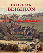
Cover illustration: 'Brighton a bird's eye view from Preston Road'. Drawn by R. Cordwell. Engraving by D. Havel
About this book/synopsis: Brighton was a decayed seafaring town in 1740, but by 1780, it had been transformed into a prosperous seaside resort that attracted two brothers of George III and many other famous people. When George, Prince of Wales (the eldest son of George III) made his first visit in 1783, Brighton was already a fashionable place to visit. By 1800, this resort was Britain's largest and most popular seaside watering place; a status that was maintained into the 20th Century.
Brighton emerged as a Georgian seaside resort during the key period of British resort development, between aboutr 1730 and 1780. Brighton's main competitors: Margate, Scarborough and Weymouth, were all developing at a similar pace, with Hastings lagging a little behind them. After 1780, however, Brighton had surpassed her competitors and had the full panoply of resort facilities. This charming and magnificently illustrated book explores why these resorts developed when they did, but also how Brighton surged ahead.
Between 1780 and 1820, the most important theme in Brighton's story is the development of new suburbs to accommodate the influx of visitors that enabled the town to prosper. Many people were needed to supply both specialist resort facilities and day-to-day requirements. Without the ability to expand, Brighton would have failed to develop as a resort. Many small businesses expanded as the town prospered and both men and women became owners of lodging houses to let. From 1820, the expectations of visitors changed, and the heyday of Georgian seaside resorts was at an end. This engaging narrative will be of interest to Brighton's residents and visitors alike, and the splendidly reproduced images will evoke a golden age for local historians everywhere.
Contents:
List of Illustrations; Acknowledgements; Introduction
1. Brighton: Fishing Town to Declining Town 1530 - 1740
2. Why Did Seaside Resorts Emerge?
3. Resort Facilities
4. Brighton's Visitors
5. The Royal Pavilion
6. The Influence of European Wars on Brighton
7. Transport Networks
8. Accommodating the Visitors
9. Developing the Suburbs
10. The Terraces and Villas of Eastern Brighton
11. The Squares and Villas of West Laine
12. Hilly and North Laines
13. Employment and Population
14. Local Government
15. Keeping the Peace
16. Education
17. Religious Buildings and their Congregations
Notes, Bibliography, Index
Illustrations Included:
1. 'A Perspective View of Brightelmston and of the Sea Coast As Far As The Isle of Wight' by James Lambert, a copper engraving, 1765. It is the earliest engraved view of Brighton and where the harvesters are working is thought to be now occupied by St James's Street and Edward Street. To the left are three windmills and perhaps James Lambert himself painting the picture in the bottom left corner
2. Sketch map with scale of Brighton in circa 1660 by Ron Martin. This was based on research using contemporary archives. Shows all the Laines: East Laines, North Laine and West Laine
3. Scale map with key of Brighton in 1744 compiled based on research using freehold and manorial records
4.
Scale map of Brighton's Laines by the 1740s
p9. Table of Brighton's population c.1565 - 1821 giving the date, number of houses (families and people, landsmen, souls in some cases) from a variety of sources
5. 'View of Brighthelmstone in Sussex' from Walpole's New and Complete British Traveller, copperplate view from 'Walpole's New and Complete British Traveller', 1784. Gives an impression of the seafront before the development of the sea defences, but after the loss of the wide beach on which small seafaring boats had been kept
6. Bathing Machines by T. Rowlandson taken from 'An excursion to Brighthelmstone' by H. Wigstead and T. Rowlandson, 1790
7. Colour illustration of Brighton Beach - an engraving by Gillray entitled 'Heat' (1810) showing ladies with parasols, boats, fishermen, bathing machines and a rather overdressed, hot, sunburned gentleman
8. Colour illustration of Circassian Ladies Corset and Seaside Bathing Dress, invented and to be had exclusively from Mrs Bell, No. 26 Charlotte Street, Bedford Square, London. Illustration taken from an unidentified book of fashion plates. Shows hooded bathing machines in the background, c.1800
9. Scale colour map of Brighthelmstone surveyed by Yeakell and Gardner, Chichester and engraved by Whitchurch, Richard Thomas bookseller, Brighthelmstone, 1 June 1779
10. Perspective View of the Steine at Brighthelmstone, taken from the South End. J. Donowel, architect. Peter Mazell, Sculptor. Colour print from a March 1778 copper plate. The key provided by the architect shows: 1. The Church; 2. Mr. Scrase's; 3. Duke of Marlborough's; 4. Mr. Philcox's; 5. Mr. Willard's; 6. The Castle Tavern; 7. The Ball Room; 8. The Orchestra; 9. Thomas's Circulating Library; 10. Hollingbury Castle; 11. Lewes Hill; 12. North Row
11. Colour print from a copper engraving from 'Guide to all the Watering and Seabathing Places', 1803. This shows the changes since 1778 such as the Royal Pavilion and the second Marlborough House and North (also Marlborough) Row
12. View of the Duke of Cumberland's house right on the shoreline with boats on the sea in the left background. This scene is in black and white and shows the house on the Steine at Brighthelmstone: artist James Luttrell; sculptor W. Watts. Copper engraving reproduced in the 'European Magazine'
in August 1786. This is Russell House, built 1753 and demolished 1826
13. Black and white print of The Castle Hotel, Brighton from an engraving in C. Wright 'Brighton Ambulator', 1818
14. The Baths at Brighton in colour. Engraved by S. Rawle from a drawing by J. Nixon, 1803
15. Black and white drawing of Mahomed's Baths, East Cliff, drawn by Cordwell and published by R. Sickelmore in the History of Brighton, 1823
16. Black and white drawing of 'The Pump House' By
W. N. Nibbs(?), c.1820. It pumped water into the baths, but was demolished in 1829
p29. Table detailing facilities like coffee houses, libraries, theatres, and Improvement Commissioners, etc., on offer at the five earliest seaside resorts in the UK (Brighton, Hastings, Margate, Scarborough and Weymouth) and showing how Brighton had taken the lead by 1780
17. Black and white illustration of Donaldson's Library from a copper engraving, C. Wright, from the 'Brighton Ambulator', 1818
18. Black and white illustration of 'The Royal Circus Riding School' taken from a copper engraving, C. Wright, from the 'Brighton Ambulator', 1818
19. Black and white illustration of the 'Brighton Races' by T. Rowlandson, taken from 'An excursion to Brighthelmstone' by H. Wigstead and T. Rowlandson, 1790
20. Black and white illustration of the library opened at the end of the Steine by Woodgate in c.1760. Miss Widgett occupied it in 1779. Bowen succeeded her and Crawford rebuilt it in 1788. J. Heath sculptor, taken from a copper engraving
p40. Table of Estimates of the Number of Visitors and the Resident Population for the years 1769, 1783, 1787, 1794, 1811, 1814 and 1817-1818. Taken from numerous sources
21. Colour illustration of 'Mrs Fitzherbert's House, Brighton', Izard St. James Street
22. View of Marlborough House, colour illustration, after refronting of the house by Robert Adam
. Mrs Fitzherbert's House is also visible. The picture is Aquatint, from c.1805
23. Sections from Yeakell and Gardner's map of Brighton in 1779 next to a section from Budgen's map of 1788 showing the Pavilion just after Holland's work on it and the development of lodging houses that blocked the Prince's view of the sea
24. Black and white architectural impression of the 'Principal Elevation of the Pavilion at Brighton in Sussex belonging to His Royal Highness the Prince of Wales.' Henry Holland architect. Richardson and Son, London, June 1796
25. Black and white illustration of 'The Marine Pavilion
belonging to His Royal Highness the Prince of Wales at Brighton.' Engraved for 'The Lady's Magazine', Copper 1799. The second Marlborough House is to the north of the Pavilion
26. Black and white print (the only one ever produced) of the interior of Holland's Pavilion, called 'Saloon at the Royal Pavilion.' It was drawn by Rowlandson and tinted by Alken
27. Colour illustration from a copper engraving of the Pavilion at Brighton by William Nelson Gardiner, engraved by Newton, 1801
28. Double page colour illustration of the 'View of the Pavilion and Steyne at Brighton with the Promenade', view by S. T. Cracklow, figures by W.M. Craig. It was etched and engraved by J. Mitan and aquatinted by J. C. Stadler, published on 23rd July 1806. It depicts the Prince of Wales and his equerry Major Bloomfield and many other notables taken from portraits by Richard Dighton
29. Colour illustration of the 'Corridor design for the Royal Pavilion' by H. Repton. Repton had the Royal Pavilion designs engraved by J.C. Stadler in 1808 (aquatint). The design was not executed
30. 'Marlborough House and Marlborough Row looking from the
North with the Pavilion just south of Marlborough House by H. Repton. Repton had the Royal Pavilion designs engraved by J.C. Stadler in 1808 (aquatint). The picture shows what it was like before Marlborough House was demolished along with the majority of the lodging houses. Repton's 'Red Book' of designs for this site from which this comes then shows his ideas for this area
31. 'The west side of the Pavilion was designed by Holland seen from just beside Porden's new Riding Stables (now called the Dome). By H. Repton.
Repton had the Royal Pavilion designs engraved by J.C. Stadler in 1808 (aquatint)
32. Black and white illustration showing 'The Pavilion, Brighton.' Bray sculp. in Attree's 'Topography of Brighton,' 1809
33. 'The Pavilion at Brighton', colour, drawn by J. P. Neale and engraved by Woolnoth in Shoberl 'Beauties of England and Wales,' 1813
34. Black and white 'View of the Pavilion taken from John Wright's Circulating Library,' May 1818.
Copper engraving, R. Alford
35. Colour illustration of 'The south front of the Royal Pavilion J. Nash Architect and inventor. Augustus Charles Pugin drew the illustration with I. Sutherland doing the Aquatint, c.1822
36. Double page colour illustration of 'The Pavilion Steyne Front' by J. Nash, the architect, with Augustus Pugin
illustrating it and T. Fidding sculp. 1824
37. Black and white photograph of No. 8, Marlborough House
38. Etching of 1794 after John Nixon in colour of 'The French Invasion' or 'Brighton in a Bustle'
39. Colour illustration of 'The Blockhouse 10 September 1773' by Godfrey, copper engraving in Grose, 'Antiquities of England and Wales', 1785
40. Colour illustration of 'Dr Syntax at a Review', drawn and etched by Thomas Rowlandson, 1813. This is a sight that would have been familiar to visitors in Brighton
41. Black and white extract from Piggott's map of 1826 showing the infantry barracks behind Marlborough Place
42. Black and white illustration of the infantry barracks behind Marlborough Place on a print of 1839, which is only one of a pair that show them clearly. 'Birds Eye View of Brighton from the New Church.' It was drawn, engraved and published by Ino Bruce, Brighton, November 1839
43. 'The Beach at Brighton, Sussex', drawn by Henry Eldridge and engraved by George Cooke, 1814 from a copper engraving
p80. Two tables showing coach services from Brighton in both 1818 and 1822 Source: C. Wright, Brighton Ambulator (1818) and Baxter's Brighton Directory (1822)
p81. Table of the Turnpike Acts for the most direct roads from London to Brighton from 1751 to 1800. Source: Turnpike Acts
44. 'Embarking for the Ferry' by T. Rowlandson from 'An Excursion to Brighthelmstone' by H. Wigstead and T. Rowlandson, 1790
45. Black and white map of the road network from London from Attree's Topography, 1809
46. List of pubs and innes in the late 1770s added to a map of Brighton by Yeakell and Gardner of 1779: 1. Half Moon, 2. King's Head, 3.
George, 4. Kings Arms, 5. White Lion, 6. Smiths Arms [Blacksmiths], 7. Coach and Horses, 8. Seven Stars, 9. New Ship, 10. Old Ship, 11. Spotted Dog, 12. The Last, 13. One Tun, 14. Gun, 15. Little Sloop, 16. Chimney, 17. Black Lion, 18. Thatched House, 19. Little Castle, 20. Star and Garter, 21. Dolphin, 22. Rising Sun, 23. White Horse, 24. Catherine Wheel, 25. Greyhound, 26. Crown and Anchor, 27. Castle, 28. King and Queen
47. The New Inn, Brighton, shown in a black and white illustration drawn and engraved by R. Alford. C. Wright, 'Brighton Ambulator', 1818
48. Black and white illustration of 'The Royal York Hotel', drawn and engraved by C. Wing, c.1830
p95. Table of location of accommodation in 1800 - old town and new suburbs, giving a split for lodgings, lodging houses, boarding houses, total advertised offering accommodation, number of houses in area and approximate proportion of houses offering or let as accommodation
p96. Table of number of houses owned, plotted against number of owners, plotted against total number of houses
49. Black and white scale map of the fields in 1792 by Ron Martin
50. Illustration and list (b&w) of the Hilly Laine Fifth Furlong owners in 1738 and 1792. This extract shows how the terrier could be used in 1792 to look up the landowners and match the information with 1738
51. Budgen's Map, black and white to scale, showing Brighton as it was in 1788 and showing the eastward's expansion
52. Cobby's Map of Brighton, 1800
53. Scale map of Brighton in 1808 by Thomas Marchant
p105. Table detailing the owners of Yardlands, 1780 and 1792 showing Name of Owner, 1780 Yard Lands, 1792 Yard Lands, Freehold or Copyhold; and Manor from which they were held
p106. Table detailing The Process and Cost of Registering Copyhold (leasehold) Title
54. Coloured map of Brighton in 1822, published in Baxter's 'Stranger in Town and Brighthelmstone Directory, 1824'
55. Colour photograph of Pavilion Parade, elegant lodging houses facing the Royal Pavilion, c.1790
p109. Table showing The Impact of Suburban Development split into Street, Old Houses, New Houses and Total Houses
56. Photograph of a mathematical tile, showing the glazed front, the profile and the pin for the nail. The tiles were nailed onto wooden lathes (strips of wood) and lime cement was used between each one
57. Black and white excerpt from Piggott's map of Brighton in 1826, showing the development on the East side of Brighton by then
58. A view of Brighthelmstone by F. Jukes in aquatint etched by S. Watts in 1785. This shows the eastern side of Brighton just as the town is about to expand
59. The Steine View of the East Side, published by E. Lay on the Steine Brighton, 1 August 1788. These are coloured etchings within washed frames - four plates were published in 1788 and two more were produced in c.1790~
p116. Table of Little Laine, Cliff Furlong from Farland to Streets split by Number on Terrier 1792, Developer, Street, Earliest Date of Mention and on What Document, Number, Street of Pauls and Street Numbers
60. Black and white photograph of Camelford Street (originally York Street). Camelford was a title of the Pitt family. Was built before 1800
61. Aquatint illustration of the 'Marine Parade from the east in c.1827' by C. & R. Sickelmore. The Albion Hotel and the Chain Pier are after 1820
62. Doorway and steps of a house in North Parade where the refacing of the house doesn't completely hide the building underneath with the door itself being typical of the late 18th Century and early 19th Century town house
63. Black and white photograph of George Street, west side, where development began in the late 1700s
64. Excerpt from Piggott's map of 1826, black and white, showing the site of Egremont Place on East Laine. When built before 1800 by a Mr. Neville, this was a villa in the fields, but by 1826, it was surrounded by development
65. Excerpt from Piggott's map showing the plan of the site of Royal Crescent in 1826 showing the gardens nearby and development eastwards
66. Excerpt from Piggott's map showing West Laine, and the old town in 1826
67. Drawn by G. Earpe with the steel engraving by H. A. Hogg in 1835, this is an illustration (black and white) of 'The Temple Grammar School Brighton'. It was designed possibly by Wilds in 1818
68. Colour drawing by R. Cordwell and engraved by D. Havel, this is 'Brighton a bird's eye view from Preston Road'. It shows North Laine being used as market gardens
69. Colour photograph of cottages built in the late 1790s on the south side of Church Street (then called Spring Gardens) and the corner of King Street
70. Drawn and engraved by Ino Bruce, this black and white illustration from November 1839 (aquatint) is a 'Bird's eye view of Brighton from the new church, at the entrance of the town'
71. North and Hilly Laines are visible in this excerpt from Piggott's 1826 map
72. Colour photograph of Bedford Square where development began before 1800
73. Black and white photograph of Russell Square
74. Colour photo of Carlton Terrace on the fringe of Hilly Laine
p137. Table of Brighton's Population and Employment by Occupational Sectors, 1783-1824, split by Sector, and the Year and Percentage Employed in Each Sector for the years: 1784, 1793, 1800 and 1824
p138. Table of Brighton Population and Occupations from the 1801-1821 census split by decade, total population, Male, Female and Profession (agriculture, manufacturing, others) with family all occupations (numbers) and average family size
p139. Table of the age structure of the population of Brighton in 1821 split by age ranges, males and females
75. Black and white illustration of Fishermen with a breeze going to sea in an engraving by Rouse, c.1810
76. Colour drawing and engraving by R. Havell, 1824 showing 'The Fish Market on the Beach' showing the Chain Pier in the background which was not constructed until 1822-3
77. Aquatint by G. Atwick, published by C.&R. Sicklemore, c1830 showing the Pavilion, the statue of the King, etc. These were built on the site of the Castle Inn in the later 1820s
78. Black & white photograph showing the refacing of the old town, early 19th Century Ship Street
79. Black & white photograph of shop fronts in Little East Street
p158. Table of the Poor Rate Assessments for the Town in 1744 split by Street, Total, Number of Houses and the Total Rate Collected
80. Black and white lithograph publshed c. 1830 of 'Phoebe Hessell', one of the Brighton residents who periodically received help from the Overseers of the Poor
81. Colour engraving by R. Havell from 1824 showing St. Nicolas Church, Brighton. Shown clearly are the external stairs to the upper gallery and its windows and the church as visitors to late Georgian Brighton would have known it. The gallery and stairs were removed in the 1850 when the church was renovated
82. Drawing and engraving (colour) by T. Rowlandson of 'Dr Syntax Preaching' in 1813. It shows a typical Georgian church interior with the emphasis on the pulpit, not the altar
83. Black and white photograph of The Friends' Meeting House in Ship Street. They moved there in 1808 but the building has been modified in the intervening years |