1973, David & Charles
In stock, click to buy for £1.85 (not including p&p)
Alternative online retailers to try:
Click here to access our prebuilt search for this title on Abebooks
Click here to access our prebuilt search for this title on Alibris
Click here to access our prebuilt search for this title on Ebay
Or try Biblio
|
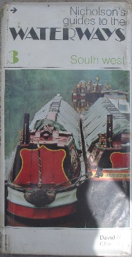
- Nicholson's Guides To The Waterways 3. The South West [top]
Edited by Paul Atterbury and Andrew Darwin
First published in 1973 in Great Britain by David & Charles, in hardback with dustjacket, 144pp, ISBN 0900568348 . Original UK retail price: £2.25
Maps are at a scale of 2 ins to the mile. Pubs, petrol stations, boatyards and miscellaneous boating facilities are all located on the maps.
Contents: ***Please note this book is likely to be out of date, although it will still contain some useful information***
The volume when published charted every BWB (British Waterways Board) navigation between Reading, Taunton, Brecon and Birmingham, on maps at 2 ins to the mile. The accompanying text describes everything of interest near the canal. Fishing notes, canal histories and practical information for boating or walking along the canals fill in the background to this comprehensive guide. It even covers the history of waterways, the practicalities of cruising pleasure craft along them, how a lock works, running aground, getting afloat, and mooring. Illustrations like navvies at work removing the stop lock at Braunston in the 1930s put lots of extra interest and colour into this volume.
Covers the following waterways: Kennet & Avon, Monmouthshire & Brecon, Bridgwater & Taunton, Gloucester & Sharpness (River Severn), Staffordshire & Worcestershire, Stourbridge, Worcester & Birmingham, Birmingham Canal Navigations, Birmingham and the Black Country, Stratford-on-Avon; and finally a useful reading list, plus list of boat clubs and canal societies; and that of the BWB Offices and Yards as existed at that time. Indexed
Nicholson have more up-to-date works on sale. Consider buying these newer Nicholson guides:
The Recent Nicolson Waterways Guide Series:
No. 1. Nicholson Guide to the Waterways: Grand Union, Oxford & The South East (Waterways Guide)
No. 2. Nicholson Guide to the Waterways: Severn, Avon & Birmingham (Waterways Guide)
No. 3. Nicholson Guide to the Waterways: Birmingham & the Heart of England (Waterways Guide)
No. 4. Nicholson Guide to the Waterways: Four Counties & the Welsh Canals (Waterways Guide)
No. 5. Nicholson Guide to the Waterways: North West & the Pennines (Waterways Guide)
No. 6. Nicholson Guide to the Waterways: Nottingham, York & the North East (Waterways Guide)
No. 7. Nicholson Guide to the Waterways: River Thames & the Southern Waterways (Waterways Guide)
|
1973, David & Charles, hbk
1973, David & Charles, pbk
|
1986, David & Charles
In stock, click to buy!
Alternative online retailers to try:
Click here to access our prebuilt search for this title on Abebooks
Click here to access our prebuilt search for this title on Alibris
Click here to access our prebuilt search for this title on Ebay
Or try Biblio


|
The use of rivers and the making of canals for transport and pleasure goes further bank in time than the c2000BC Mr Hadfield has chosen as a convenient starting date. Because of this, many people consider inland waterways to be an old-fashioned way of carrying goods and passengers-until they see for themselves the freight traffic of rivers like the Mississippi, Rhine, Volga or Yangtse, and canals such as the Kiel, Amsterdam-Rhine, Albert, Welland or Panama, or indeed the pleasure craft that pass England's Stoke Bruerne, the Dutch meers or along America's Atlantic Waterway or Canada's Rideau.
From Portugal to Brazil, from Belgium to India, the United States to Italy, the Netherlands to Zambia and China to Romania, canals or river navigations have recently been opened, or are currently being built or enlarged. Our own times are also seeing the revival, and indeed restoration, or smaller canals as cruising waterways and national parks. Simultaneously, an astonishing range of working craft is being developed to meet today's and tomorrow's needs.
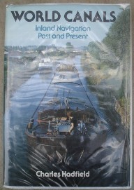
Charles Hadfield, author of British Canals (7th Ed.), has here written what is believed to be the first book to outline the story of inland navigation around the world. Well-illustrated and supplied with maps, World Canals offers enthusiast, student and general reader alike continually interesting and sometimes surprising insights into the pattern that carriage by inland water-oldest and yet in some ways most modern of modes, eternal tortoise of the transport world-has imposed upon time and space.
Contents:
List of illustrations
Preface
The Old World
1. Beginnings to 1519
Before the Romans; Roman Times; Change in China-Development in the Dark Ages; River Navigation in the early Middle Ages; Staunches, flash-locks and inclines; Canals and pound-locks; Leonardo da Vinci
2. Merchants and Princes, 1519-1759
France: to the Canal du Midi and beyond; Schelde and Meuse; The astonishing Dutch trekvaarten; Berlin, a waterway city; A trans-Sweden canal is attempted; Peter the Great: canal-builder; English river engineers foreshadow her canal age
3. Bridgewater to Von Platen
The Bridgewater Canal and its effects; Sea to sea across Denmark; Waterways for coal; canal-cutting in Spain; Louis XVI of France: young man in a hurry; Prussia builds eastwards; Progress in Russia; The stillness of China; The interruption that was Napoleon; Boat-lifts and inclined planes; Britain's canal age; Europe after Napoleon; After Napoleon: France; After Napoleon: the Dutch-Belgian kingdom; Swedish achievement
4. Transformation by Steam
Changes in passenger transport; steam changes the waterway balance; waterway development in Russia and Finland; steamboats in India; steamboats in Western Europe; steamboats and improvements on the Danube; early railways influence river improvement; have canals a future? canals in the Low Countries; Canals in Germany and Sweden; Canals in France
5. What railwaymen would have thought it?
Ship canals become the rage; PIANC a symbol of engineering advance; Disenchantment with railways; Chain and cable haulage; Channel improvement and lock-building on the larger rivers; Push-towing; River age succeeds canal age; improved traction; better channels and new technologies: lifts, inclines, aqueducts; the British explore foreign waterways
6. To 1914: France to the Aegean
France; the Low Countries; Germany:1871-1887; Germany, the Kiel Canal; Germany: 1887-1914; Italy; The Danube and Balkans; the Corinth canal
7. East and South, 1869-1945
Finland; Russia; Iraq; British India; Ceylon (now Sri-Lanka); Burma; Siam (now Thailand); Indochina; China; Japan; Australia and New Zealand; Africa: the Nile; Africa: Central, West and East
8. Interlude Between Wars
The Rhine; The Rhône; France; The Low Countries; Germany; The Rhine-Main-Danube canal; Czechoslovakia; Sweden; The Danube
9. Since 1945: Broad Waterways
War divides Europe and changes the Old World Standardisation and barge operation; Container-carrying; New barge types and overcapacity; some survivals; short-sea traders, coasters and sea-going barges; barge-carrying ships; the main lines; the ship canals; waterway structures; pleasure craft
10. Since 1945: Kaleidoscope in Water
Britain; France; the Low Countries; Germany; Switzerland; Italy; Portugal and Spain; Yugoslavia; Czechoslovakia; Poland; Finland; Russia; India; Pakistan; Bangladesh; Burma; China; the Nile; West, Cnetral and East Africa; Envoi
The New World
11. Early Days
Canals for Canoes; to Ohio and Mississippi; Fuel for Philadelphia; canal and lock companies; a national waterway policy takes shape; happenings in Nova Scotia; steamboat days; the war of 1812 and waterway development; the Welland canal and the St. Lawrence; the Ottawa-Rideau defence route; the Erie Canal
12. Consequences of the Erie
The link to Lake Champlain and Canada; the Canals of the Eastern Seaboard; Atlantic Intracoastal beginnings; Canals to the West; Canals of the Mid-West; Back to the Erie; Canadian developments; the Great Lakes; The Canal Age in North America
13. Rivers, Railroads and War
The Western Rivers to the Civil War; Railroads and Canals in the Nineteenth Century; The Coal-Carriers of the East; The Atlantic Intracoastal Waterway; Steam on the Western Rivers, 1865-1900; Changes in Canada; St. Lawrence to the Soo; Watershed
14. Waterways Develop: Panama to the Lakes
The Isthmus; New York State Barge Canal; Roosevelt in 1907; The Chicago Ship Channel; The Great Rivers to 1914; The Great Rivers, 1914-1945; The Atlantic Intracoastal Waterway achieved; Georgian Bay plans and Welland action; Steamer Days on the Lakes; The Trent-Severn Waterway; The Steamboats' work is done
15. Since 1945: South and West
The system expands (Gulf Intracoastal Waterway, Ohio river; Arkansas river; Tennessee-Tombigbee Waterway; Willamette, Columbia and Snake rivers); channel depths are standardised; technology moves on (towboats, barges, ship-barge transfers; barge-carrying vessels; tug-barge systems
16. Since 1945: Seaway and on
The St. Lawrence Seaway; Rivers to the Arctic; Canada's Canals for Pleasure; The Atlantic Intracoastal Waterway; The New York State Barge Canal; The West Coast; Conservation and Recording; Present and Future.
17. Latin American Coda
Acknowledgements; Sources of Quotations; Index
|
1986. Facts-On-File Inc
1986, David & Charles, hbk
Other books of interest:
|